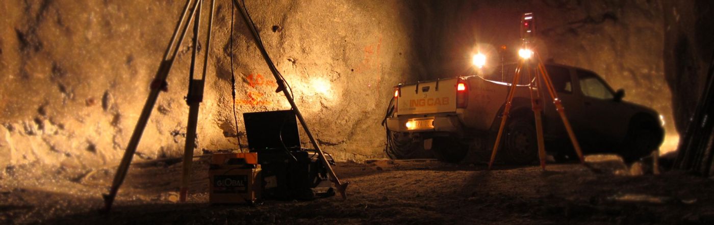
VZ-400 3D Laser Scanner

The V-Line® 3D Terrestrial Laser Scanner RIEGL VZ-400 provides high speed, non-contact data acquisition using a narrow infrared laser beam and a fast scanning mechanism. High-accuracy laser ranging is based upon RIEGL's unique echo digitization and online waveform processing, which allows achieving superior measurement capability even under adverse atmospheric conditions and the evaluation of multiple target echoes.

VZ-400.jpg

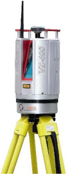
The line scanning mechanism is based upon a fast rotating multi-facet polygonal mirror, which provides fully linear, unidirectional and parallel scan lines. The RIEGL VZ-400 is a very compact and lightweight surveying instrument, mountable in any orientation and even under limited space conditions.

Modes of Operation

  • Stand-alone data acquisition without the need of a notebook, basic configuration and commanding via the built-in user interface
  • Remote operation via RISCAN PRO on a notebook, connected either via LAN interface or integrated WLAN
  • Well-documented command interface for smooth integration into mobile laser scanning systems.
  • Interfacing to Post Processing Software

User Interfaces

  • Integrated Human-Machine Interface (HMI) for stand-alone operation without computer
  • High-resolution 3.5" TFT color display, 320 x 240 pixel, scratch resistant cover glass with anti-reflection coating and multi-lingual menu
  • Water and dirt resistant key pad with large buttons for instrument control
  • Loudspeaker for audible signaling of messages by voice
googleads.g.doubleclick.net/pagead/viewthroughconversion/967329451/?value=1.000000&label=fE4fCI2JygkQq42hzQM&guid=ON&script=0"/>
Laser Product Classification Class 1 Laser Product according to IEC60825-1 :2007
The following clause applies for Instruments delivered into the United States;
Complies with 21 CFR 1040.10 and 1040.11 except for deviations pursuant to Laser Notice No. 50, dated June 24, 2007.
Temperature Range 0ºC to +40ºC (Operation)
-10ºC to +50ºC (Storage)
Protection Class IP64 (dust and splash-proof)
Weight Approx. 9.6 kg
Angular Stepwidth Horizontal (Frame) Scan: 0.0024º ≤ Δ Ø ≤ 0.5º (between consecutive scan lines)
Vertical (Line) Scan: 0.0024º ≤ Δ ϑ ≤ 0.288º (between consecutive laser shots)
Max. Measurement Range The following conditions are assumed:
Flat target larger than footprint of laser beam, perpendicular angle of Incidence, average brightness
  • As-Built Surveying
  • Architecture & Facade Measurement
  • Archaeology & Cultural Heritage Documentation
  • City Modeling
  • Tunnel Surveying
  • Civil Engineering
  • Very high speed data acquisition
  • Wide field-of-view, controllable white scanning
  • High-accuracy, high-precision ranging based on echo digitization and online waveform processing
  • Multiple target capability
  • Superior measurement capability in adverse atmospheric conditions
  • High-precision mounting pads for optional digital camera
  • Integrated inclination sensors and laser plummet
  • Integrated GPS receiver with antenna
  • Various interfaces (LAN, WLAN, USB 2.0)
  • Internal data storage capability
Laser Pulse Repetition Rate (Peak)1 High Speed Mode: 300 kHz
Long Range Mode: 50 kHz
Effective Measurement Rate2 Long Range Mode: 222,000 meas/sec
High Speed Mode: 222,000 meas/sec
Max. Measurement Range for Natural Target ρ ≥ 90%3 Long Range Mode: 2000 m
High Speed Mode: 2400 m
Max. Measurement Range for Natural Target ρ ≥ 20%4 High Speed Mode: 1000 m
Long Range Mode: 2300 m
Max. Number of Targets per Pulse5 Practically Unlimited
Accuracy6 5mm
Precision7 3mm
Minimum Range8 1,5m
Laser Wavelength9 Near Infrared
Beam Divergence10 0.3 mrad

1 With Online Waveform processing - Rounded Values 
2 With Online Waveform processing - Rounded Values 
3 With Online Waveform processing - Typical values for average conditions. Maximum range is specified for flat targets with size in excess of the laser beam diameter, perpendicular angle of incidence, and for atmospheric visibility in excess of 23 km. In bright sunlight, the operational range is considerably shorter than under an overcast sky.
4 With Online Waveform processing - Typical values for average conditions. Maximum range is specified for flat targets with size in excess of the laser beam diameter, perpendicular angle of incidence, and for atmospheric visibility in excess of 23 km. In bright sunlight, the operational range is considerably shorter than under an overcast sky.
5 With Online Waveform processing - Details on request.
6 With Online Waveform processing - Accuracy is the degree of conformity of a measured quantity to its actual (true) value. One sigma @ 100 m range under RIEGL test conditions
7 With Online Waveform processing - Precision, is also called reproducibility, or repeatability, is the degree to which further measurements show the same result. One sigma @ 100 m range under RIEGL test conditions
8 With Online Waveform processing
9 With Online Waveform processing
10 With Online Waveform processing - 0.3 mrad correspond to 30 mm increase of beamwidth per 100 m of range.

Scan Angle Range Horizontal (Frame) Scan: Max. 360º
Vertical (Line) Scan: Total 100º (+60º/-40º)
Scanning Mechanism Horizontal (Frame) Scan: Rotating Head
Vertical (Line) Scan: Rotating Multi-Facet Mirror
Scan Speed1 Horizontal (Frame) Scan: 0º/sec to 60º/sec
Vertical (Line) Scan: 3 lines/sec to 120 lines/sec
Angle Measurement Resolution Horizontal (Frame) Scan: better 0.0005º (1.8 arcsec)
Vertical (Line) Scan: better 0.0005º (1.8 arcsec)
Inclination Sensors Integrated, for vertical scanner setup position
GPS Receiver Integrated, L1 antenna
Compass Optional, for vertical scanner setup position
Internal Sync Timer Integrated real-time synchronized time stamping of scan data
Scan Sync (optional), scanner rotation synchronization

1 Frame seen can be disabled, providing 2D operation